This module allows you to trace the journeys described in the text, to learn about routes and destinations, the means of transport used, and land travel as well as oceanic navigation.
Contents: the narrative on navigation includes the following:
Part 1: The Geography of the Anglo-Saxon World
Part 2: Navigation in the Middle Ages
Part 3: Journeys Described in Our Texts
Part 4: Navigation and Motivation
You can get to any of these parts from any point in this document by selecting the appropriate hyperlink, or you can read the parts sequentially.
To learn about the LINKS and IMAGES that accompany this narrative, click on the appropriate hyperlink. We recommend that you consult "So What?" after you have read one or two parts of the narrative below. Note that the sources used in the narrative are listed in the Bibliography and are cited here only by author and page or by author, title, and page.
"Navigation" comes from two Latin words, "navis" meaning "ship" and "agere," meaning "to drive." Navigation seems to be a subject primarily concerned with water--and in SEAFARER is primarily seen as marine--but it obviously encompasses finding one's way on land and in the air as well. Navigation, as an intellectual exercise, means to use the known to explore the unknown, and it is that sense that SEAFARER is a "navigational" program designed to help its user connect familiar information to information that is new.
In this and in other modules, we find it necessary to begin with reference to the structure of the Roman Empire, which encompassed Europe and, at the end of the fourth century, much of the Middle East. At this time monasticism had already taken root in Egypt and Italy. England was recognized as a diocese of the Roman Church, but the impulse behind the mission from Rome that resulted in permanent conversion of the island to Christianity had not yet begun to form (that mission from Gregory the Great to England departed Rome in 596). Rome was about to fall to the Visigoths, who sacked the city in 410 A.D., the year Rome began to withdraw troops from Britain. This phase, "Roman Britain," was followed by the arrival of the Angles, Saxons, and Jutes by sea from the Continent and the subsequent development of "Anglo-Saxon England." See LINK 1. Rome was destroyed by the Vandals in 455, after which point barbarian invaders ruled the West. By 476 the Roman Empire of ancient times had come to an end. (IMAGE01 not yet available in the program)
The fall of Rome was an important event in Anglo-Saxon history. Bede's History explains the function of Roman troops as protectors of the British against northern invaders and the chaos that followed when the Romans withdrew (see the early chapters of Book of Bede's book). The world of Rome also figures into one of our SEAFARER texts, the Voyages of Ohthere and Wulfstan, which would seem to have very little to do with the world of Rome. But the accounts of these navigators are found in a text known as the Seven Books Against the Pagans, a history of the world by the monk Orosius written to refute charges by non-Christians that Rome fell because it had been converted to Christianity (as we explain in the Introduction to the Voyages). The Old English translation of the World History was obviously conceived of as a very different kind of document from the Latin original in one respect at least: it was meant to serve as a compendium of geographical knowledge about the known world, and since it was particularly deficient in details about the northern parts of Europe, the Voyages were added to fill an important gap.
By the time of Ohthere and Wulfstan, however (the end of the ninth century), knowledge about navigation was widely diffused throughout European civilizations. What kinds of voyages from earlier periods do we know about? We know that the Vikings first appeared in England around 800; Viking raiders destroyed the monastery at Lindisfarne in the mid-ninth century; a Viking voyage to Iceland was recorded in 860. But the Vikings found that they were not the first visitors to Iceland, nor indeed the first navigators of the northern waters.
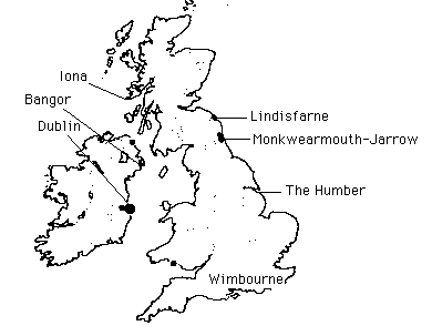
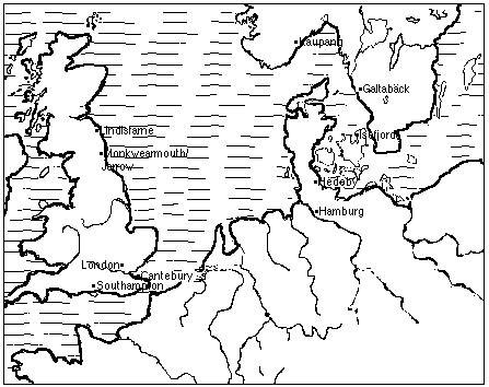
That distinction belongs to an unlikely crew indeed: Irish monks. The voyages of the Irish are probably not as early as the legendary voyage of St. Brendan would have us believe--that is, as early as 520-550 A.D.--but there is little doubt that Irish monks were taking to the seas in the late sixth and early seventh century. See LINK 2. Irish monks are said to have settled the Faero islands as early as 700-725 A.D. H. H. Lamb, whose study Climate, History, and the Modern World is the source for much of our information in this module, believes that the Irish were emboldened to sail into northern regions because the migration of birds indicated to them that land could be found in that direction (164-65). The Irish made their way in stages of 200 to 300 hundred miles to the Faero Islands, which are between Great Britain and Iceland, and to the Shetland Islands, off the northwestern coast of Scotland. You can see the links between England, Ireland, Scandinavia, and North American destinations in this map (IMAGE02 not year available in the program). Off Scotland the Irish founded the famous monastery at Iona, discussed by Bede as "Hii" (Book 3, ch. 3). (IMAGE03) You can find Iona on IMAGE01 (not year available in the program) and IMAGE06 also; it is the northernmost point on each.
One of the most important documents for understanding the relation of Rome to Anglo-Saxon England, and for grasping Anglo-Saxon views of the world more generally, is known as the "Cotton Tiberius" map, so named because it is the manuscript Cotton Tiberius B.V in the British Library. This map shows that the world was thought to be surrounded by the ocean. (IMAGE04 not yet available in the program) The map shows how England was thought to be related to other lands, including Ireland ("Hibernia"). A close-up view (inset) shows that even England is distorted and indeed that the entire continent of Europe has been pulled out of shape, with the Iberian peninsula ("Ispania," bottom center) nearly touching the extreme southern and western parts of England (Lund 11).
The development of navigation as a body of transmittable information depended on the understanding and codification of geographical and meteorological signs. Navigation is the art of traveling to a known destination by means of reading signs and steering according to them. It is an art that depends on texts to transmit it, of course, although in this and other cases oral transmission initially sufficed. The Voyages of Ohthere and Wulfstan are good examples of such records; so clearly do they depict the routes traveled that scholars have never been in much doubt about the direction and extent of their journeys.
Our knowledge of navigational science in the Middle Ages reflects what we know about sailing in the ancient world. In Ships and Fleets of the Ancient Mediterranean, Jean Rouge inveighs against several stereotypical ideas about navigation in the ancient world. Some peoples, he notes, are considered to be "naturally" seafaring--e.g., the Greeks--while others are averse to travel on water--e.g., the Romans (11-12). It is also thought that mariners in the ancient world were afraid of the open seas and that they sailed only in daylight (for technical reasons including unresponsive steering) and that their ships had small tonnage capacities. Rouge insists, to the contrary, that sailors in the ancient world were of practical mind and that they preferred water (sea or river) transport to land transport wherever the former was the cheaper (14); that they sailed capably night and day; that the rudder of ancient ships was as good as the sternpost rudder developed in the Middle Ages; and that the ships' capacities were large--carrying, for example, cargo of some 50,000 bushels of grain (15).
How did early navigators know about their world and how did they steer around the obstacles to their destinations? Their navigational instruments were simple but effective. Navigators used the sun and stars and the directions of the winds to steer and recorded landmarks so that others could use them. Navigational instruments include the wind rose or rosa ventorum, which identified the wind by eight names, according to the directions from which they blew, and the compass. Scholars are not clear on the stages in which the compass developed. You will note that the DMA says flatly that the compass (consisting of a magnetized needle mounted on cardboard) was brought by the Arabs from China (DMA 89). The Macro Encyclopedia, however, is more cautious, saying that the compass was used by the Chinese around 1100 A.D., by western Europeans in 1187, by Arabs in 1220, and by Scandinavian sailors by 1300 (751).
Navigational guidebooks were also available. Rouge calls our attention to one particular source we might not otherwise consider in the study of medieval seafaring: written guides for sailors. Such texts, called the Circumnavigations, began to be recorded as far back as the fourth century B.C. They describe dangerous areas (e.g, rocky coasts), landmarks, ports and the products to be found in them, and information about winds and currents (18). Such sources tell us that seafaring is a subject that produces its own, distinctly "non-literary" and very practical literature, and also reminds us that such texts--which we think of as technical manuals--are associated with many kinds of trades. The accounts of the travels by Ohthere and Wulfstan are a valuable example of such texts.
One of the technical ideas important to take into account is the use of time to measure distance. We will see time used this way in the accounts of both Ohthere and Wulfstan. Obviously sailing depends on the wind rather than on-board power. As Rouge writes, we must not "speak of the speed of a crossing, but only its duration" (21). Rouge gives the example of St. Paul's sailing to Italy in Acts 27:1-10. (IMAGE05 St. Paul's Journey to Italy, not yet available in the program.) See LINK 3. Eventually the use of time to measure distance was replaced by more precise methods than the unit of a day's worth of sailing. The use of the terms "knots" to express distance--still in use--marks a late stage in navigational science, however. In 1637 an English navigator called Richard Norwood began using a line knotted at intervals of about 50 feet (actually 47.25 feet); this line was tied to a log that was dropped into the water and its units were measured in knots as the ship left the log behind (Macro 751).
You will find that almost all general discussions of navigation connect this topic to two others: climate and trade. There are many obvious reasons for these links. Climatic conditions, including everything from wind conditions to the amount of ice blocking open seaways, clearly dictate the conditions of marine navigation. Changes in climate might force the migration of a people or at least might spur searches for certain raw materials or foodstuffs suddenly made unobtainable. Nations with early histories of seafaring frequently have narrow coastal regions bordered by mountains--precisely the conditions we see described by Ohthere in his voyage, describing the camps of the Finns along the sea (Para. 1). Ohthere also reported that "the land of the Norwegians is very long and narrow" and that "all of it that can be used for grazing or ploughing lies along the coast and even that is in some places very rocky" (Para. 6). Inhabitants of such areas took to the sea in order to obtain products they could not grow and to procure food from the sea. Navigational history is closely connected to land geography and climate.
Changing climatic conditions had much to do with when and how navigators began to travel in the waters of northwestern Europe and the British Isles and beyond. Lamb believes that much of the period with which our SEAFARER project is concerned was characterized by a general warming of the climate in northern Europe, making expeditions into new territory possible. Lamb writes that the period from 770-800 A.D., when the Carolingian Empire was being established (by Charlemagne or Charles the Great), evidently witnessed unusually severe winters (163). It is one thing to speculate on such winters, which are reported in narratives from the period, and another to explain why severe winters might have been more frequent at this time. Lamb suggests that "anticyclones" might have blocked "the westerlies" (that is, westerly winds), with the result that extremes in weather conditions were not moderated. He writes that the spread of Viking voyages from 790 onward "north into the Arctic and west to Greenland, and ultimately to Newfoundland and apparently into the Canadian Arctic north of Baffin Island, surely owed a great deal to the long period of retreat of the sea ice and probably a relative immunity from severe storms" (165). When the ice returned about 1200, navigators' routes had to move increasingly southward; eventually contact with Greenland became impossible.
Lamb notes that North America was discovered by Vikings c. 1000, probably by accident when ships were blown off course. Only one settlement, in Newfoundland, has been discovered. Apparently the settlers found it difficult to displace or integrate with native populations, Lamb suggests. Only one settlement is known in Newfoundland, at L'Anse aux Meadows. Attempts to settle North American were abandoned until the fourteenth century (166). Lamb cites much evidence of climatic change that would have altered these adventures, however. The waters off west Greenland were apparently warming at that point, since the sailors found many codfish there, and Norse burials took place "deep in ground which has since been permanently frozen" (166).
The change in climate affected more than navigation, of course, as Lamb's work shows. We note that Ohthere mentions agricultural activity near Trondheim, in northern Norway, a region in which, according to pollen studies, cultivation ceased in the thirteenth century. So the voyage of Ohthere supplies useful information about agricultural patterns as well as navigation (Lamb 168).
The texts in SEAFARER 1.1 have been selected in part because they describe journeys along popular routes in the Middle Ages. These include travel between England and Rome, England and the Continent (especially Germany), England and Ireland, and England and Scandinavia.
One of the earliest, and perhaps the most important journey in this period, was the mission from Rome to England undertaken by Augustine (not the St. Augustine of the Confessions) at the direction of Pope Gregory the Great. Augustine left Rome in 596 and arrived in Canterbury in 597. His route took him to Lerins, a monastery off southern France, then to Marseilles, Vienne, Chalons, Tours, and from there to Canterbury. (IMAGE05 -- not year available in the program) Augustine's itinerary indicates that he made visits at several important courts where he represented the Pope's interests and no doubt negotiated on the pontiff's behalf with regional officials.
We should not take the complexity of Augustine's journey for granted, either as an effort to navigate the distance between Roman and Canterbury, or as a diplomatic undertaking. Bede tells us that Augustine carried several letters from Pope Gregory to bishops in Gaul (France today) that were designed to reinforce papal connections in these areas. These letters (which Bede read and included in his History) concerned various matters, including the governance of the Pope's estates in southern Frances (near Arles and Aix). (IMAGE06) (See Hunter-Blair, 49-55.) It is clear that the Pope was also concerned that Augustine's mission to England be received and understood in the context of papal will. Augustine, as a new ambassador, lacked authority of his own, and the Pope's letters were designed to demonstrate his trust in Augustine both as leader of the new mission to England and as a messenger carrying out the Pope's wishes in various churches and courts.
Augustine's route went through France, up the Rhone to the mouth of the Seine (modern Etaples, at the mouth of the River Canache, known to Bede as "Quentavic"). The area around Canterbury was very important to commerce and travel in the Anglo-Saxon period. Canterbury provided an excellent harbor in a "sheltered waterway system" linking Scandinavia, England, France, and territories beyond. Between Canterbury and the sea is the Isle of Thanet (Hill 14). (IMAGE07 not yet available in the program) Bede describes Thanet as occupied by about 600 families (Book 1, Ch. 25). The island was important as part of a toll system regulating trade along this important route and is a rich site of coin deposits (Hill 14).
A later, very elaborately documented journey from England to Rome is that of Archbishop Sigeric, who in 990 went to Rome for his pallium (symbol of episcopal authority) and whose itinerary is an exceptionally rich source for our knowledge of contact between England and Rome in the late Old English period. See the essay by Veronica Ortenberg in the Bibliography.
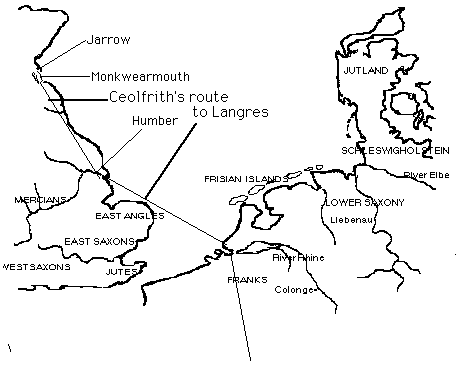
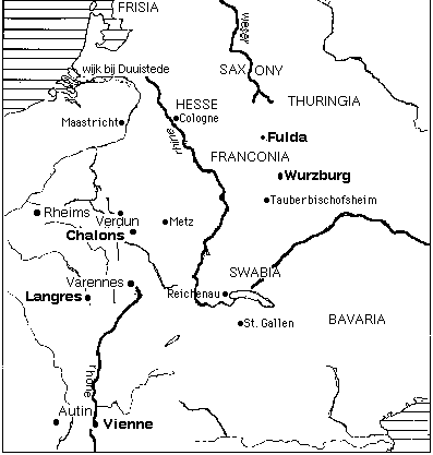
The first SEAFARER text reverses the journey from Rome to England. Ceolfrith undertook a journey from Monkwearmouth / Jarrow to Rome in 716. The Life of Ceolfrith recounts his expedition, which ended with his death in France, and also refers to regular travel by Benedict Biscop and others between England and the continent. Ceolfrith's route took him from Monkwearmouth / Jarrow south, by land, to the Humber River, and thence through three provinces to Gaul. Ceolfrith thereby traveled via the most important harbor in England for departures to the Continent. We know that the missionaries Wilfrid (in 678) and Willibrord (in 690) traveled to Frisia from this port and that a century later Alcuin departed from this point to visit the Franks. (IMAGE08 not yet available in the program) Ceolfrith's route took him towards the kingdoms of the Franks, located south and west of Frisia. (IMAGE09) Ceolfrith died at Langres, which is on the River Marne. (IMAGE10)
The physical details of Ceolfrith's voyage are, unfortunately, scarce. We see that preparations include some diplomatic considerations, since Ceolfrith "drew up a list of envoys whom he intended for Rome." As he prepared his ship, he "procured a sufficiency of the things which might be necessary for so great a journey." But, unfortunately, we have no details; the author finds it equally important that the material preparations included "the gifts which were to be rendered to the blessed Peter" (22). Indeed these were important, since they included the Bible manuscript known as the Codex Amiatinus. (For more about this book, see section 5 below.) We know that Ceolfrith set out on June 4, on the fifth day of the week (31). This text is an unusually good source of navigational information, since it indicates destinations and routes to them, including some harbors, rivers, and other navigational points of reference. We know that Ceolfrith traveled with a retinue of 80 men. A month after he left Monkwearmouth-Jarrow, on July 4, a Saturday, he left the port at the mouth of the Humber for Gaul, visiting three provinces before he arrived in Gaul August 12. Thus we see that it took approximately a month for Ceolfrith to travel from Monkwearmouth to the Humber, where he obviously had to wait for a ship. The journey to Gaul was not direct, since he made three stops en route. In Gaul he was received by "Helperic," whom we know as Chilperic II, king of Neustria (d. 720). Travel in this text does not stop with the death of its major figure, however; the author notes that after Ceolfrith was buried, some of his followers returned to England, while others--bearing the gifts, the Bible among them--continued on to Rome.
We do not know where Leofgyth began her journey, although presumably she set out from Wimbourne, which is located near the southern coast of England, in the 740's. Her cousin Boniface set out from this area in 716, the same year Ceolfrith left for Italy. She lived and taught at a monastery at Tauberbischofsheim, in central Germany. Our map also shows the location of Fulda, where Boniface worked and where Ceolfrith was buried with him after he was martyred in Frisia. (IMAGE10)
The Voyages of Ohthere and Wulfstan not only describe voyages but discuss the technology that made sea travel possible. We know that the presence of these narratives in the Old English translation of the World History of Orosius is further testimony to the importance of navigation in this period, since the travelers described their adventures in Scandinavia during their visits to the court of King Alfred.
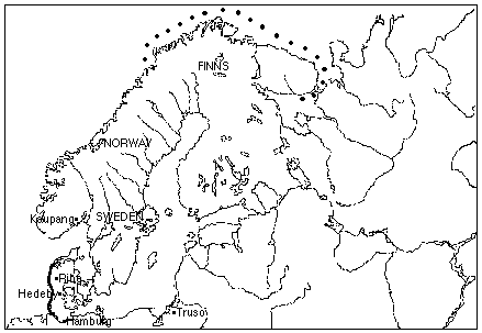
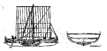
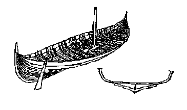
Ohthere's first voyage took him to the northernmost reaches of Norway and Sweden, where he sailed in order to find if those points were inhabited. (IMAGE11) Ohthere's second voyage, reached from Hedeby, in Denmark, to three ports in Norway and Sweden--Kaupang, Galtaback, and Isefjord. Hedeby was also Wulfstan's point of departure. (IMAGE12) Ohthere's ship was a cargo boat, possibly similar to the deep-sea ship known as Skuldelev 1. (IMAGE13) This was not the only kind of cargo ship available, however; another, somewhat different in its configuration, is known as the Klastad merchant ship. (IMAGE14)
Among the navigational features you should note is the use of time to measure distance. We learn in para. 2, for example, that Ohthere sails for three days, not that he covers a certain number of nautical miles. Again, in para. 3, we learn that he sailed for five days. We also learn that it can take two weeks to cross mountain ranges and that, for sailors, these boundaries mean that boats must be carried (6). Ohthere explores for commercial reasons. He knows that the walruses in this area have fine ivory tusks, and he brings some of this ivory to King Alfred as a form of tribute (4).
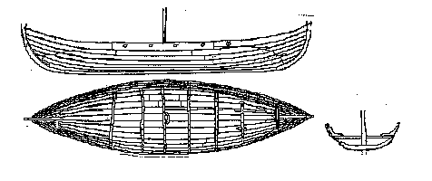
Wulfstan's voyage is identical in this respect, measuring distance in terms of "seven days and nights" (10). But in the main, even though he too was a merchant, Wulfstan's voyage differs from Ohthere's. Navigational techniques for Wulfstan's voyage include the use of lead plumbs such as those illustrated in a drawing from the Bayeux tapestry. (IMAGE15 Not yet available in the program.) Sailing required the use of the "plumb" technique during voyages at night to prevent ships from running aground. Wulfstan's voyage took him from Hedeby, sailing along the northern coast of what is now Germany and Poland. (IMAGE16) Wulfstan's ship was possibly of the type illustrated by this example, a ship found at Rugen, which is a point on Wulfstan's voyage directly south of Sweden. (IMAGE17)
The Colloquy also raises questions about the commercial activities associated with fishing. Fishing is one of the occupations discussed in greatest detail. The speaker prefers to fresh-water fishing because it is much safer than fishing on the high seas. The monastic master asks his "pupil-fisherman" about such matters as the cleanliness of fish (para. 55) and their marketing in the city, where fish are sold. We also learn the names of fish caught in both fresh and sea waters (62, 66), and why this particular navigator-fisherman avoids hunting whales: they are so large that they are dangerous to hunt (70-72), and this reminds us that in the Voyages we learn how large some whales are (up to 50 ells).
The Dream of the Rood gives us an entirely different perspective on navigation in this period: navigation as a metaphor for the soul's journey from life on earth to the afterlife. There are two kinds of journeys referred to in the poem--literal voyages and missions, and those that are metaphorical. Examples of the former are limited. We know that the cross is carried (line 30, "enemies seized me . . bore me on their shoulders"), that the Lord rushes to the cross (line 34), and that His retainers from "from afar" to the site and then want to leave (57, 68). But most references to travel in the poem are to its spiritual meaning: when Christ dies, he "sends forth his spirit" (49); he ascends to Heaven (103), and likewise every soul must go "through that cross" "from the earth to seek the kingdom" (119). That is the journey that the dreamer contemplates (124) and he envisions his arrival in heaven--as he saw Christ's--as a homecoming. The poem shows that, paradoxically, one cannot reach his or her home without leaving it--that is, cannot find eternal peace without giving up security on earth. Given how unhappy this dreamer seems to be, of course, it seems that for him (or her?) earthly happiness has already lost its meaning.
Navigation is large topic not only because navigational science is complex but because so many sources about navigation are stories about voyages: they are travel literature. Some travel literature is valuable because it tells us about the relation between navigation and commerce. IMAGE18 (Not yet available in the program) shows both links between Scandinavian countries and the British Isles, and between the British Isles and Greenland, including L'Anse aux Meadows. The map shows the chief goods as well as the routes used for trading them. We have seen that Thanet, near Canterbury, was important as a site for collecting tolls from traders; our map indicates the location of an eighth-century toll station. (IMAGE07 -- not yet available in the program)
An association between navigation and communication is another direction we have only begun to explore here. The importance of the Bible manuscript that Ceolfrith planned to take to Rome will be discussed in another module, "The Manuscript Book." This book, the Codes Amiatinus, is enormous: it weighs 75 pounds, and some 500 calves were needed to supply the parchment on which it was written. See LINK 4.
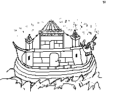
Navigation is represented in still different terms in the Life of Ceolfrith, where it takes a form we might think of as more figurative than literal. Take a look at what is probably the most popular image of seafaring in the Middle Ages--Noah's ark (we have an Anglo-Saxon example). You see here that the image is a of a church mounted on a contemporary ship. (IMAGE19) The Life of Ceolfrith refers to both figurative and actual voyages; it concerns means of transportation, routes, and other details that indicate the material requirement of traveling from England to Italy. You should consider the relation between the figurative importance of the voyage in this text and in some Old English poems, such as "The Wanderer" and "The Seafarer," in which the voyage into exile is both literal and figurative. See LINK 5.
The figurative navigation in the Life of Ceolfrith is reinforced by the author's references to certain activities undertaken en route. For example, the text observes that not only "his egress from life devoted to God, but also his entry and his progress in it ought duly to be traced, and the constancy of his unfeigned faith imitated" (1). Ceolfrith's life, therefore, is seen metaphorically as a journey, a figure of speech making use of the pilgrimage, one of the most popular spiritual and literary motifs of the Middle Ages. See LINK 6. At the end of the Life we learn that Ceolfrith was an "exile for Christ" (30). The author mentions that at Ceolfrith rarely missed saying Mass during his voyage. This observation indicates that it was difficult to observe the liturgy while traveling (33).
Finally, navigation has important implications for our understanding of the politics of the medieval and early modern worlds. Even though Ohthere does not know exactly where he is, he seems to know that navigational rights are not automatic. Rather, they depend on settlements and that settlers in a given area control the rights to sail their waters. When Ohthere came to a river he dared not sail up it without permission (3).
Our knowledge of medieval navigation, climate, and trade depends on many small but revealing historical facts. For example, scientists have several reasons for believing that sea levels were generally higher in the Middle Ages than they are now. One of these involves the success of Hereward, an English thane from Lincolnshire who represents the last native English resistance to William the Conqueror. Strange though it may see, for ten years after William defeated Harrold at the Battle of Hastings in 1066 Hereward held out on the Isle of Ely; because of higher sea levels, the isle was actually divided from the mainland, but it no longer is. See LINK 7. Such basic material conditions have shaped the course of history more directly than we might imagine.
1/98