IMAGE01 Centers of monastic life, c. 250-735 A.D. Source: Brooke, p. 16, Fig. 2. Not Available At This Time.
IMAGE02 Map of eastern France and western Germany. St. Gall is located in the bottom center, directly south of Lake Constance. Horizontal lines in the upper left indicate the English Channel and those in the lower right indicate the Gulf of Venice, the northernmost part of the Adriatic Sea. Source: Hill, plate 242, p. 149.
IMAGE03 The Plan of St. Gall, shown in overview.
IMAGE04 The Plan of St. Gall, showing the entrance for visitors.
IMAGE05 The Plan of St. Gall, showing the central section.
IMAGE06 The Plan of St. Gall, showing schools and the buildings reserved for the sick and the dying.
IMAGE07 The River Tyne and Monkwearmouth-Jarrow.
IMAGE08 Map of England, the Netherlands, northern Germany, and southern Scandinavia. The location of the monasteries of Lindisfarne, Monkwearmouth-Jarrow, and Wimbourne are shown (also London, Canterbury, and Southampton. Source: Hill, plate 202, p. 120.
IMAGE09 Map of France and Germany, showing location of famous monastic and ecclesiastical centers such as Trier, Mainz, and Tours on rivers. Source: Hill, plate 208, p. 124.
IMAGE10 An Anglo-Saxon water mill. The water in this drawing flows through the lower rectangle around the mill paddle, turning the stones in the upper chamber. Source: Rahtz and Bullough, figure 2, p. 30.
IMAGE11 This is a reconstruction of a building in Chalton, Hampshire, showing the use of individually set posts. The superstructure (roof, walls, beams, etc.) is conjectural. Source: Addyman, fig. 9, p. 303.
IMAGE12 This reconstruction of a building in Chalton, Hampshire, shows posts set into continuous trenches and walls made of wattle. The superstructure is conjectural. Source: Addyman, fig. 10, p. 305.
IMAGE13 This building from St. Neots, Huntingdonshire, shows a house with ground-sills; the superstructure is conjectural. Source: Addyman, fig. 11, p. 307.
IMAGE14 This reconstruction shows different periods of construction at Monkwearmouth. The dark areas show building from the early Anglo-Saxon period. Source: Wilson (Cramp), plate 5.9, p. 230. Not Available At This Time.
IMAGE15 This drawing shows a reconstruction of Jarrow, with the darkest lines indicating the earliest Anglo-Saxon construction. A closer look at Room B is available in IMAGE16. Source: Wilson (Cramp), plate 5.12, p. 237. Not Available At This Time.
IMAGE16 This drawing gives details of Building B in IMAGE14, showing three rooms in Room B (living room and two-part oratory or prayer room with opus signinum floor. Source: Wilson (Cramp), plate 5.13, p. 238. Not Available At This Time.
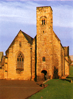
IMAGE 17 St. Paul's church at Monkwearmouth-Jarrow. The cornerstone of this church was laid by Abbot Ceolfrith (see the Life of Ceolfrith in Texts). Only the current west front of the church is original seventh-century construction.
1/30/98